


One Week, Three Linkups.
They say that limitations are a great source for creativity. I’ve tried to espouse that belief in my photography, and I also am learning to embrace it in my athletic pursuits. In the same way that the pandemic lifestyle taught me to view my immediate surrounding through a creative lens as an exercise in necessary right-brain stimulation, it has also given my formerly globe-trotting body a smaller but deeply engaging sandbox in which to play. The accumulating experience and the quantifiable scope of the local mountains, as defined as the areas accessed via Snoqualmie Pass, or via one of the other forks of the Snoqualmie River, have made it possible to begin to understand a vast, complex wilderness landscape. To go from a life of rambling widely and ‘just scratching the surface’, to a life of deep immersion, and a sense that I’m finally seeing how the puzzle fits together.
What does this mean in practice? That through a decade or more of significant ski touring and ski mountaineering outings in the area, and three years of nearly monogamous adventuring in these hills, I’ve seen enough views of enough of the slopes, in enough different conditions and times of year, with robust photographic documentation of all of the above, that I am building a mental map of the landscape that feels to be growing in value through intimacy.
For each set of conditions, I’m closer to having educated ideas about the best terrain fit. One of my favorite exercises for testing these theories seems to come regularly in January in the Cascades. It’s not inconsistent that our generally frequent storms stop for a week or two and are replaced with a stable high-pressure system accompanied by an strong inversion, creating stable, springlike conditions up high, and dismal cold, foggy conditions in the valleys. The resort skiing generally doesn’t thrive in these conditions, but the ski touring, and especially the ski mountaineering can be enjoyable to outright sublime.
In these conditions, as opposed to the rest of winter, you needn’t tiptoe carefully and slowly into the upper reaches of these mountains, ever vigilant of the slightest signs of instability. This snow is locked down, and you can range around like a wolverine with crampons and ice axes as claws.
Of note. I am using the names and reference points represented on modern maps, at the expense of referencing the original names. I support the Snoqualmie Tribe Ancestral Rights Movement, and hope to learn and share more indigenous names and stories as I deepen my understanding of the true roots of our local culture.
The CUSP (Commonwealth Ultimate Summit Progression)

Peaks of the CUSP: Guye Peak, Snoqualmie Mountain, Lundin Peak, Red Mountain, Kendall Peak
I realized a few days into the weather system that while I’d skied extensively off of Guye Peak, Snoqualmie Mountain, Lundin Peak, Red Mountain and Kendall Peak, I hadn’t been to the true summit of a couple of them, and seldom visited the summits of a couple of others. I wondered if I could ski all of the mountains in a single day, and make sure to hit the true summits.
Drew Tabke, a former resident connoisseur of the Snoqualmie zone was easily sold on the idea during his recent visit and we set forth at about 6am bound for Guye Peak. We approached via the commonwealth basin and climbed the north ridge route up Guye to the north summit. From there, we skied down the prominent east couloir for a few hundred feet, then climbed back up the south tending gully back up to reach the middle summit. Another short down and up brought us to the south, and true summit. There were ample very steep snow slopes, and a couple of knife-edge steps, but we both felt totally safe unroped with crampons and single axes, as well as the use of skis. While this felt reasonable to us in these conditions, I’ve seen the same route in extremely dangerous and unstable states, complete with bus-sized cornice hazards.
We exited Guye to the north, traversed the west end of Cave Ridge, and began up the south ridge of Snoqualmie Mountain. Consistently steep, but very straightforward climbing brought us to the summit of Snoqualmie. Snoqualmie is a large, broad mountain with an immense variety of options for ski descents, but surely one of the least exciting, but most efficient is the massive traverse one can make to the east in order to gain a high position on the climb up Lundin Peak’s Cocaine Gully.
Thanks to said efficient traverse, we found ourselves with a very quick, perhaps 500’ boot pack up Lundin Peak to the saddle. We carried skis until the rock fin became prominent, then dropped skis and packs, setup a belay, then simulclimbed a mix of rock and snow to the summit. I climbed in crampons, Drew in boots only. I was the happier of the two, as the wet slabs were at points engaging, but the protection was ample in the form of some large, strange bolts installed as a tribute to a fallen climber. A rappel with a single 30m rope got us off of the ridge and back on snow. We attempted a high traverse across the rocky spines to the left of the Cocaine Gully, but they did not go through with current coverage so we headed down below the cliffs until we could access a notch to the pond below Red Mountain.
We were into the afternoon hours by the time we began skinning up the lower flanks of Red on a well established skin track. Eventually the track terminated at a solid boot pack, and the upper thousand feet or so were an efficient staircase. By this time in the day, on the legendary corn run that is the west face of Red, we were not alone. We probably interfaced with 12-15 people on the climb and/or summit. Vibes were high, and we moved on pretty quickly, as Kendall was looking far, and hours were growing long. We decided to see what the true south face of Red would serve up, as it had the potential to put us in a high position on the north side of Kendall. It took some scratching around, but we were able to find and ski the furthest viable passage up the valley toward the PCT, which saved climbing Kendall from the valley bottom.
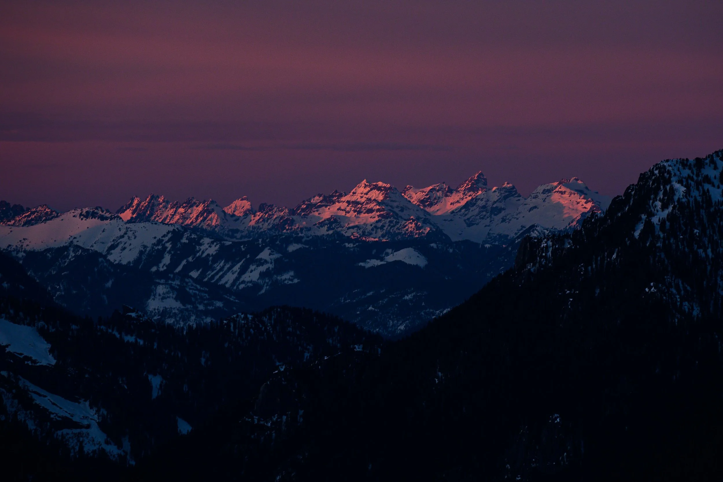
The peaks of the Monte Cristo range bathed in pink light at sunset as seen from the summit of Kendall Peak
Steep skinning through the big forest on the north slopes of Kendall brought us to the prominent fin on the NW corner, then around to a sparsely treed upper west face. We traversed across this face using a combination of skinning and ripping the skins for sliding traverses, all the while trying to hold or gain elevation. It was kinda slippery, and kinda far, so we were happy to finally reach the final bit and a sunset summit experience. The descent of the upper west face, and the prominent slide path were excellent corn which transitioned to dangerous, crusted, breakable mank with enough depth and rigidity to cause some serious problems. Cautious movements brought us to the pathway exiting just skiers right of the big waterfall, and then on to the standard PCT exit of the Commonwealth Basin.
Five summits, aspects that cooperate with the movement of the sun, movement ranging from casual to technical, and some fantastic views and corn skiing make this tour a highly recommended classic. It’s not often that these mountains make themselves so available in the wintertime, it’s an absolute pleasure to visit robustly when they do.
Kaleetan to Granite

Kaleetan Peak (back left) to Granite Mountain (foreground) - A corn skiing dream tour
Probably the first time I heard of the Kaleetan to Granite traverse was from Kyle Miller’s trip report. Then it stayed off the radar for quite some time until last winter, when I found myself trying to draw interesting lines on the map of the local mountains and realized how cool it was to link those peaks. Without digging into the subject too deeply, I launched on that mission last year with Nick Aadland. We had a lovely time. I promised myself I’d repeat it in the future.
Last week it seemed that conditions were ripe, so the hunt was on for a willing victim, er, partner. I took a ‘Max, we should rip together soon’ Instagram message and turned it into a ‘Lets get weird and really tax the concept of efficient split boarding’. Theres a certain kind of person that I always choose when I look for mountain partners. They smile while they grunt. They realize that the whole damn thing is just a lark, so you might as well have fun. Max Djenohan is that way. We have fun.
Timing is everything on this one. It’s a corn mission. Three corn runs are the justification for this 11 hours of movement. Too early, hard snow. Too late, dangerous snow and headlamp skiing. We decided on 6am for a car drop at the Granite Mountain Trailhead off of the Denny Creek exit. A quick jaunt up the pass had us departing from Alpental roughly a half hour later.
The ski from Alpental to the summit of Kaleetan is possibly the coolest bit of steep ski touring in the Snoqualmie mountains. I wish I could see this for the first time, again. Terrain of astounding beauty and severity revealing itself in layers, culminating in the unfathomable chute terminating on the true summit of the peak that the indigenous people called Arrowhead. A vantage from which a person can see 4 volcanos and more daggers of rock and snow than the mind can digest in a single sitting. Or even a lifetime of sittings.
Also, it’s a corn factory. Rocky fringes baking in the sun on aspects varying from pure south to SE or SW depending on time of day and the foot you prefer to stand on for your surf turns. We went right to hit a particularly ripe wall. It was kind. We aimed for the catch basin below the peak where we transitioned briefly to skinning, then to booting in order to efficiently gain the furthest south point on Kaleetan’s south ridge. This unlocks a 2200’ corn run all the way to the forked sources of the Pratt River, which were easily crossed on snowy logs.

Max Djenohan surfing the corn on the south face of Kaleetan Peak
Here’s where my personal approach to this tour may differ from the norm, and may not actually be the recommended solution.
Low mountain is called as such, but I don’t buy it. It seems kinda large and a bit in charge. I have been aiming for a weakness at about 4300’ on the ridge of Low in order to make an efficient traverse on to Tuscohatchie Lake from which the Granite climb begins. I’ll say this once here, but will stand behind it until I die, the snow conditions in the shade were deeply fucked during this weather window. Max, bless his heart, was pretty much confined to wearing ski crampons on his split board for the duration of the tour, and was none the fresher for it. So the ridge was hard earned, and we reached the lake just as the last slivers of sun were making their exits for the day.
We had the good fortune of running into tracks here, which were left by Kyle McCrohan and crew a few days previous. Tracks make navigation easier, but the refrozen ice glaze on said track made the walking a bit less-so. Tooth and nail, to the top of Granite as the light turned pink, and all but the highest peeks began to go into shade.
The greatest treat was still to come.
Pink. Fucking. Corn. The skiing was excellent down the central south face. It was ripping. At the main funnel, we stayed the course, following an increasingly thin snowpack on the skiers right side of the creek. At the final waterall, where the right side is dense forest, or certain death, we crossed the creek and linked thin patches of snow down the final step, finally connecting with the trail at the very lowest switchback. Through the use of sport-utility skis, I was able to ski the entire way to the parking lot without taking my skis off. Max resorted to a few short walks, and some extremely impressive one-legged pogo moves across wet stones while fully strapped in with one foot.
It was dark at this point, but only the trail segment required headlamps, and it was a brief need indeed. The shuttle back to Alpental is crazy quick, and we were all home in time for dinner.
CBT. It’s like CBD - super good for you. Calms you down.

Chair Peak (right), Bryant Peak (center), The Tooth (Left) as seen from the NE ridge of Chair Peak
All I do is stare at the NE face of Chair Peak. I’ve been obsessed for years. Somehow, I’ve never climbed it. I’ve been so attached to it as a ski objective, that I’ve only been interested in the perfect day of snow for skiing the line, and haven’t really even seriously considered climbing it just for the sake of climbing it. Well, with no snow in the forecast, and two cool linkups already in the bag for the week, I though there was room for one more. This one with a bit more climbing and a bit less skiing. But definitely another distinct line to be drawn on the topo.
I suggested the idea of linking Chair Peak, Bryant Peak and The Tooth in a single-day winter tour to Matt Henry. He told me that we probably needed to wait for longer days. He had said the same thing about the CUSP tour. I’m stubborn, so eventually he was talked into it.
On Friday, 1/27 we left North Bend around 5am and were moving on skis up the Alpental valley by 5:45. In the dark, foggy morning, even the familiar route to Chair Peak basin was a little difficult to discern, and the snow was massively slick; ski crampons were an absolute must. We broke out of the fog around mid mountain and the yellow to indigo hues of pre-dawn were capped by a sliver of moon over the ramparts of the Tooth. Astonishing daybreaks are truly one of the most potent motivators for early starts. They can be so rewarding.

Dawn breaks with a sliver of moon above the fog in the Alpental Valley
Not long after sunrise we were caching ski gear and transitioning to crampons and ice axes for the final climb to the base of the NE Buttress. The snow was well compacted, and the track was set, so we were able to move quickly to the foot of the climb. We used a running belay to the in-situ anchor at about halfway up the right side pitch one variation. We belayed a short pitch through the corner of snow and rock leading to the standard p1 anchor in the robust trees. We simulclimbed to the base of the ice step using slung trees and a couple of pieces of rock pro. Matt took the lead up the ice, first casual, then pitching to slightly overhung for a body length, before relenting to solid snow. He protected the crux with a single screw and a fixed piton, the anchor above was a picket backed up with both of Matt’s axes. We simulclimbed the upper snow pitches, then dropped the rope at the false summit and scrambled easily to the true summit. It was about 10:30am with strikingly beautiful weather, we were pleased.

Matt Henry at the base of the ice step on the NE Buttress of Chair Peak in the Alpental Valley
We tinkered with the wrong south facing gully for a bit before descending the correct one with a mix of rappelling and down climbing. The penultimate rappel took us halfway down a steep narrow couloir which was then descended with steep down climbing on a mix between ice, crust and powder. Soon we were back in the basin and putting the skis back into service.
We decided to keep the crampons on for a climb up a steep ramp which accesses a bench system high on the east face of Chair Peak, which can be crossed to access the Bryant Col. I had hoped to climb Bryant Peak via the north face route which I had skied with Erik Svege a few years back, but the rock step at the bottom was looking massive and imposing, and we opted for a route with a higher likelihood of success within our timeline for the day. Kinda decent skiing down from Bryant Col took us to a gateway to the south face where we did a short bit of steep skinning through the forest, then some very friendly movement through open meadows. Once we were fall line below the line we intended to ski on Bryant, we dropped our packs, and skinned up Bryant’s south face in a very casual mode. Packless, unencumbered, with sunglasses on our faces, climbing perfect corn snow. We call it Cali style. It feels good. Soon we enjoyed fantastic views off the summit, and skied some of the finest corn of the week back to the packs.
It was a little hacky, and a little side-step intensive, but we were able to cut a contouring traverse that put us at the base of the west face of the Tooth. From there it was a quick boot pack to the notch below the south face. It was now about 2:30pm. Boots off. Rock shoes on. We simulclimbed our way up about half way before running out of slings and swapping leads. Quick work was made of warm dry stone with small patches of snow walking through well established bootprints. There is a special part of heaven that is made up of alpine rock climbing in winter in kind conditions. It’s just so enjoyable. Always feels like you’re getting away some some kind of trick. We laughed. Then we descended via the standard rappel stations back down the route.
Packs were repacked with skis strapped on as we utilized the bolted chain anchor to rappel down the narrow descent couloir. It was a free-hanging rappel off of a big cornice. Not something I’d normally do, but things were feeling astonishingly solid back there. The rope ran out at a perfect alcove below some rocks, were we hopped on the skis for the exit.
Bad, unpredictable, firm skiing through various states of visibility were augmented with some alpenglow, and some endorphin glow. We slid up behind my truck just as headlamps were to become imminent. Perfect timing.
Wrap-up
Within a single week, and just 3 days of skiing, I was able to reach 11 major summits, three of which I’d never visited in my life, and drew three very enjoyable and uncontrived lines on the map. Each with its own flavor, each highly recommended. When the snow stops falling, don’t mourn the powder. Embrace the stable surface, and see where you can get your body to go!

Leave a comment
This site is protected by hCaptcha and the hCaptcha Privacy Policy and Terms of Service apply.