


How do you take somewhere known for being crowded and expensive and make it lonely and cheap? Go in the shoulder season, and spend your nights in a sleeping bag. Such was my strategy for an extra week in Lofoten, Norway after I wrapped up a commercial shoot in the islands. Wanting to keep things simple, I came up with a plan that could be done with some grippy shoes and a small overnight pack. I’d take a bus to the far point of the Lofoten peninsula, then set out with a lightweight backpacking and light mountaineering kit with designs on a human-powered traverse of some of the most amazing parts of the Lofoten, namely the islands of Moskenesøya and Flakstadøya, collectively referred to as the West Lofoten.
The internet being the amazing tool it is, I typed in ‘Lofoten Traverse’ and quickly landed on the Rondo Lofoten site, an amazing resource for all things backcountry travel in Lofoten, and specifically, including a beautifully designed route connecting the entire Lofoten peninsula with as much trail, and as little road and water travel as possible. Their site includes information on resupply points, public transportation options and even downloadable GPS tracks of the route. In its entirety, the route takes the better part of two weeks, while I had only 6 days to work with. With that in mind, I took to Google Earth, and quickly discovered that the westernmost islands on Lofoten are stacked with jagged granite peaks, white sand beaches and smaller population centers. Perfect. Using the Rondo Lofoten route as a starting point, I then stumbled on an amazing trip report on The Hiking Life that opened up some alternate options bypassing some boat travel in exchange for some off-trail mountaineering. I also discovered an amazing resource for photographers, hikers, campers and peak baggers on the 68north site, by photographer Cody Duncan. His West Lofoten downloadable PDF book proved an invaluable resource anytime I decided to improvise routes outside of the Rondo Lofoten track.
For those of you who still have an appetite for the written word, I’m happy to give a bit of a day-by-day breakdown with some highlights, lowlights, and maybe some tidbits that will help in your future endeavors. If digesting by moving pictures is your jam, I made a little video journal of the trip you can enjoy here.
Without further ado.
Day 1 Sørvågen to Bunes Beach via Munkebu
Day one was for speed. There is an energy that I have had the privilege to enjoy. It’s an energy inspired by, and reserved for, the mountains. No matter my level of fatigue or exhaustion related to sleep, work stress, etc. in the ‘real’ world. If I am lucky enough to step full heartedly into the mountains, I tap into a seemingly bottomless wellspring of energy and passion. When loosed from the leashes of day to day, I stride out like the hounds on a hunt. All panting breath and miles underfoot. But all that had to wait for a solid 3pm start, after working through a bunch of computer time from the work assignment, seeing the crew off to their flights, securing fuel and food, dropping luggage at a safe spot for after the hike, and getting into position at the bus station, followed by a 3 hour bus ride. But once at my trailhead in Sørvågen, I noted the late hour, and the lack of nice food for the next four days, and decide to sit down for a pint and a very good burger at the beautiful Maren Anna restaurant on the pier before setting out. Decisions like this are made much easier when the sun never sets, so there is no such thing as being benighted in the mountains. You just go with what feels good.
Well fueled and full of stoke, I launched on the well marked, and well maintained trail from Sørvågen toward the Munkebu hut, which lies on a beautiful bench between the peak of Munkebu, and the azure waters of Tennesvatnet lake below, much of which was covered with snow and ice at this juncture. Snow, trail and grass travel provided a beautiful alpine ramble to the north end of the lake, where the trial system takes a deep dive from the lake plateau down to the power station at Forsfjorden. This would be my first sampling of proper bog walking, mixed with exceedingly steep trail, and slippery granite slab. Rugged, nasty work. The shoes would be fully saturated by the end of this descent, and illusions of well-trodden trails would be displaced by something less pleasant, and more open for interpretation. And yet, this descent through funky ground was offset by the waterfall cascading the full height of the neighboring mountain, and the turquoise shallows in the fjord below. Shin-deep mud and uncertain footing seemed a small price to pay.

Tennesvatnet Lake above Forsfjorden
Mountainous shorelines being renowned for adding more complexity than a map would indicate, the segment of rugged trail between Forsfjorden and Vindstad was a mix of light bushwhacking and heavy scree rambling. At the small hamlet of Vindstad, the character of the trail changed immediately into a glorious well-marked, well-trodden, and even in place cobblestoned highway to heaven. Nothing could have prepared me for the first revelation of Bunes Beach as I crested the pass in golden 10pm light and took in the soaring granite walls diving directly to a white sand beach. Sublime is the only word I can offer. It fails miserably to match the power of this place and time.
Instead of seeking a home on the beach, I climbed a few hundred feet to the prominent knob in the Trolldalen basin where fresh snowmelt cascaded through golden grasses and the sunshine would last until 2am before finally sliding behind the eastern mountains on the far side of the beach. Here, I did my best to absorb this once-in-a-lifetime scene with my eyes, my heart and my camera, before finally collapsing from exhaustion once the sun pulled behind the mountains.

Midnight Sun on Bunes Beach
Day 2 Bunes Beach to Horseid Beach via Helvetestinden
On day 2, I woke to swirling clouds and soft breezes and decided to take a lightweight pack for a quick scramble to the top of the impressive granite dome to the west of Bunes Beach, which is a sub summit of Storskiva. The early season conditions kept things spicy as there were still unreliable snow patches hovering on slabs of wet, steep granite, and even steeper grass and heather. Relying on light footwork, and aided by an ice axe and trail spikes, I gained the summit and was rewarded with views of the ocean to both sides of the peninsula as low clouds danced on the surrounding summits.

Morning light from Storskiva sub-summit
After descending and breaking down camp, I strolled down to Bunes Beach proper and was immediately captivated by the beauty of the patterns as black and white sand were braided together by the perpetual movement of water and wind. To each side of the beach, soaring granite walls which could have been pulled straight out of Yosemite Valley. After a full survey of the beach, I aimed for the trail to the Helvetestinden saddle.

Sand patterns on Bunes Beach
My initial plan included a visit to the summit of Helvetestinden, but upon reaching the pass, I was greeted by gentle but increasing precipitation, and I decided that if I were to pursue my route plan, I’d need to do it as quickly as possible before it got too dangerous. The route from the saddle down to Kjerkfjorden is a cross-country adventure with significant exposure, and difficult ground. A faint trail leads one to a series of short, but very exposed gulleys of grass, heather and rock. A slip would be fatal. The axe and spikes again proved invaluable for providing traction in a critical spot. Below, the slope angle eases significantly, but the terrain remains challenging as large scree fields covered with thick moss, which hide all kids of traps, give way to a densely forested bog before finally relenting on the shores of Kjerkfjorden.

Kjerkfjord from below Helvetestinden
This shortcut can be easily bypassed by utilizing the ferry, as outlined in the Rondo Lofoten route. This is recommended for people uncomfortable with exposed mountaineering, or if conditions are slippery due to rain or snow.
Upon reaching the hamlet of Kjerkfjord, I followed the beautiful, rambling trail toward Horseid Beach, always with my eyes magnetically pulled toward the spectacular east face of Breidflogtind, a stripped wall of immaculate granite. At this point, wind was becoming a factor. Instead of the spectacular, but exposed camping options on the beach, I opted for a protected meadow near the outlet of the Horseidvatnet lake, where a beautiful cascade would sing me to sleep.

Meadow camp above Horseid Beach
Day 3 Horseid Beach to Kvalvika Beach via Markan
Incredible mountain travel is the treat of the day when traveling from Horseid Beach to Kvalvika beach. A steep, muddy trail climbs efficiently to Fageråskaret Pass, where side missions to the neighboring peaks is highly recommended. There is a huge, overhanging boulder near the pass which makes a great gear cache, allowing for a lightweight pack for peakbagging. I opted to attempt a linkup of Markan and Branntuva. Markan is easily climbed via an established climbers’ trail up its obvious east ridge. Descending Markan directly to the north toward Branntuva is enjoyable and beautiful, but does require a couple of moves of exposed low 5th class down-climbing. Alternatively, one could reverse the Markan route and take a low traverse to the south ridge of Branntuva. The south ridge is a strange landscape of moss, scree and boulders. I became increasingly untrusting of the moss as I stepped through solid looking patches into ankle-grabbing holes in the buried rocks numerous times on this hike. The summit of Branntuva is broad and beautiful and has spectacular views of all of the finest elements of the Lofoten experience; white sand beaches, turquoise waves, granite big walls, craggy summits, alpine lakes, and indigo fjords. More than an eyeful. The peaks on the opposite ridge across Fageråvatnet Lake are supposed to be just as spectacular, but alas I needed to keep on the move.

Horseid Beach from Branntuva
The hike from Fageråskaret Pass to Selfjord begins steep and boggy, then gets rambly and boggy. By far the wettest bit of hiking of the trip. And yet, such beauty as one descends from the craggy alpine into the subalpine gardens below. The moist ground was literally exploding with spring growth as countless species of fern and wildflower covered every inch of the landscape, often overshadowed by the twisting, wind-gnarled trunks of arctic birch trees. Intermittent brooks cascading from the lofty peaks to the north provided ample thirst quenching, and a primitive toilet near the trailhead was a special treat after three days of cat hole digging.
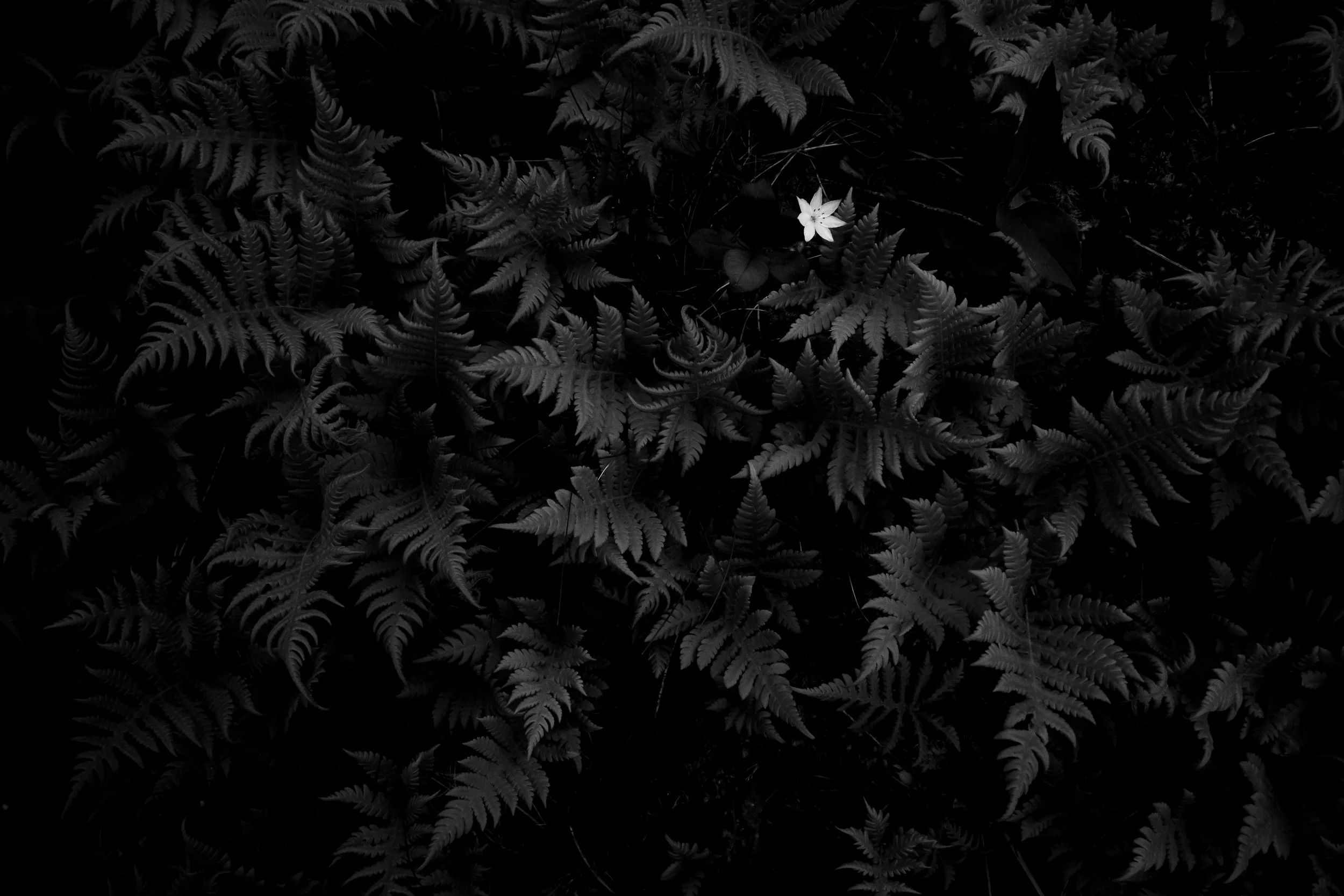
Ferns with white flower
Eventually, the boggy ground gives way to a couple of larger stream-crossings and a gravel lane with limited trailhead parking. 2km of walking this road would lead to the lesser-used trail to Kvalvika Beach via the shores of Markvatnet Lake and Ågovatnet Lake. This trail is easy to follow, and moderately rugged. Perhaps its finest feature is that it arrives at the more secluded western Kvalvika Beach, which is less popular than the main beach to the east, and is separated by a rocky headland of moderately difficult hiking. I had this beach entirely to myself and pitched the tent on a beautiful grassy plateau overlooking the crashing waves just as the rain began in earnest.

Camp on Kvalvika Beach
Day 4 Kvalkia Beach to Skagsanden Beach via Ryten
Turns out, if you’re trying to find people, this is the place. After seeing a grand total of 7 people in the first three days on the trail, on this day from Kvalvika Beach to the summit of Ryten and down to the trailhead at Fredvang, I’d see maybe 10x that number. The downsides of this popularity were instantly visible. Signage about water borne bacteria in the streams (after having been deeply enjoying the unfiltered lifestyle thus far on the trip), countless braided ‘alternate’ paths up the mountainside of Ryten. This zone is heavily impacted in a way that was unique on this trip. That said, I can see the reason for the popularity; it’s undeniably spectacular.

Ryten from Kvalvika Beach
After traversing the headland from the quiet side of Kvalvika Beach to the busy side, I walked the beautiful white sands before joining a steep trail alongside a cascading stream up toward the Ryten climb. Where the trail crested the steep hillside from the beach, it joined an amazing raised boardwalk which saved endless steps in the deep boggy ground below. The boardwalk led to a pass near Forsvatnet before joining the aforementioned array of trails up to Ryten proper. I chose the furthest climber’s left trail in order to enjoy the massive views and wild exposure on the edge of the climb.
Here are the iconic Lofoten images you’ve seen sprayed across social media. Unlikely, death defying perches standing proud of the sheer face of Ryten and overlooking a fantasyland of glorious natural wonders. Just add yoga pose on the edge, voila. And yet, the allure of the place is undeniable, and soon enough, I, too was perched upon a sheer edge, asking a passerby if they might be willing to snap a quick photo. Trends are trends for a reason.

Kvalvika Beach from Ryten
The descent from Ryten was quite beautiful, mixing rugged mountain trail with elevated boardwalks and rolling granite domes, before finally terminating in idyllic farmland on the coastline near Fredvang. I could have found a bivy spot in the vicinity, but the allure of fresh European pilsner beer, a hot meal and a roof over my head was enough to motivate a 10k road walk through Ramberg to the perfectly executed Lofoten Beach Camp. This amazing destination hosts tent-campers, van campers and those looking for a simple room in a hostel setting, and provides an amazing common area complete with a restaurant, lounge and sauna, all in a gorgeous modern A-frame building facing an inviting surf break. What’s not to love? Nothing. Nothing at all.

Lofoten Beach Camp
As I settled in for a night of sleep in a small but comfortable bed, pulling the curtains closed against the endless daylight, gale-force wind and rain lashed violently at the windows, and I was so happy to be right where I was.
Day 5 Skagsanden Beach to Tønsåsheia via Innerfjorden
As with all things in life, there is a price to pay for comfort and joy. In this instance the price was 20km of road walking from the Lofoten Beach Camp south to the first gateway to the high country that seemed viable for a solo traveler with limited equipment. This walks was at times sunny with wind, rainy with wind, scenic with wind, and glorious with wind.
Where the Rondo Lofoten route had the traveller walking around the entirety of the peninsula via Nesland, my maps and eyes presented another option. It appeared that Tønsåsheia could be climbed from the west via a potentially moderate drainage and upper basin. While no trail existed, it looked reasonable on a map, and continued to do so upon closer examination from below. With nothing to lose and endless daylight in the bank, I began the steep clamoring through dense ferns which were on the edge of going full height and rendering off-trail travel near impossible.

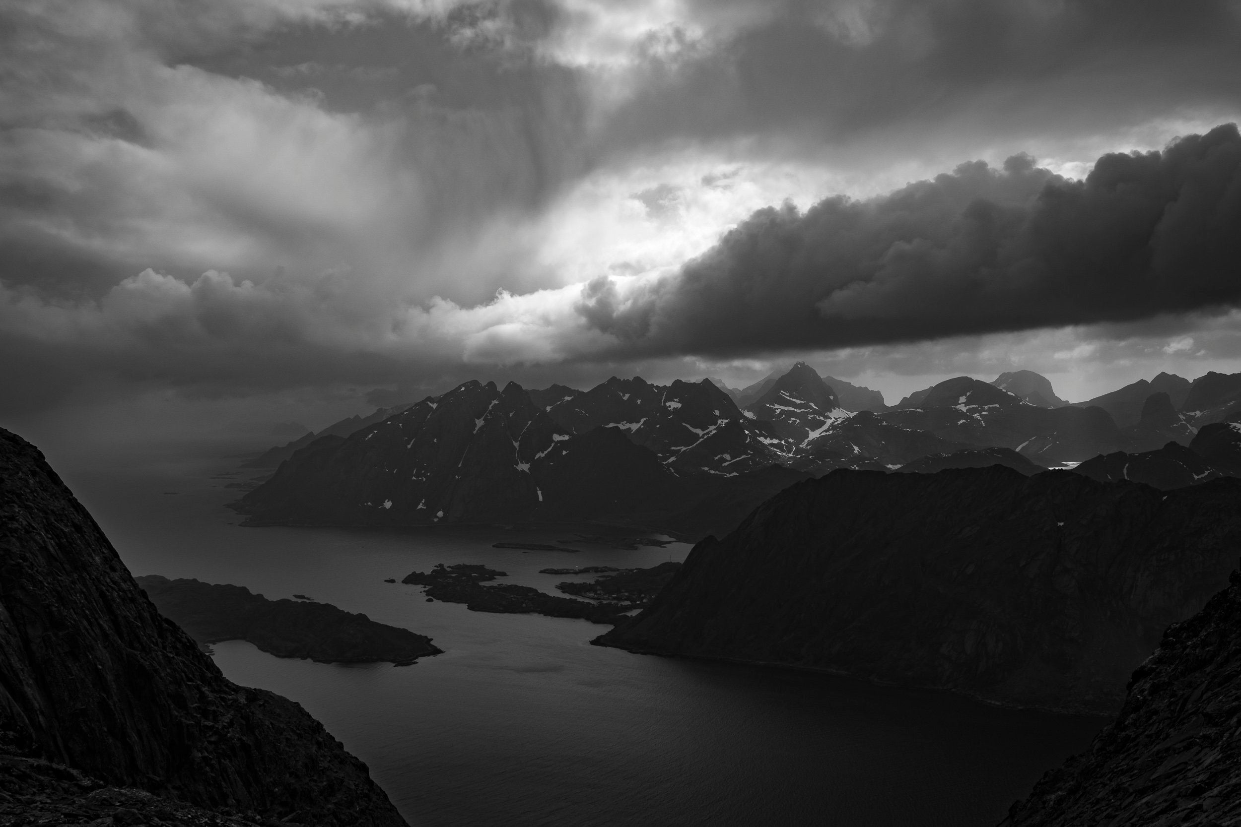
Dramatic weather in the West Lofoten
A couple of rowdy stream crossings and one step of steep climbing yielded a beautiful upper cirque which offered steep, but very straightforward snow climbing to the summit ridge, which is shared by a number of minor summits in addition to Tønsåsheia. As the Norse gods of wind, rain and sun battled for supremacy, I bounded from summit to summit, drinking deeply of the fleeting final days of my trip and wondering how I was going to hide from the weather.
I finally settled on a small nook near the ridgeline bordered on one side by a wall of stone and on the other by a deep wind-drifted snowbank. Thirty minutes of hacking with the adze on my ice axe yielded enough space to pitch my tent in this confined space, which felt well protected against the winds, which were already steady at 25mph, gusting to probably 40mph, and forecast to increase. I was feeling pretty smart as I set out from camp to photograph the spectacular scenes of hail, wind and rainbows under the light of a four hour sunset/sunrise.

Magic light over Skjelfjorden
A short time later, crawling into my tent wetter than a Norwegian sheep dog, I was feeling a little bit less smart. The wind had turned and was now slamming full force into the foot of my tent. A relaxing night this would not be.
Day 6 Tønsåsheia to Napp via Nusfjord
I woke to a cold, damp morning of low clouds hovering around the peaks, ever swirling under the power of the still stout wind. Feeling uninspired, I trudged through the fog for a bit before breaking out below the cloud deck to a sunny day that nonetheless required trekking poles to keep from being blown over. The view to the south of Nusfjord tucked into a deep, rocky cove kept me moving toward better conditions.

Looking down on Nusfjord and the east coast of Flakstadøya
Walking out of the woods and into Nusfjord was like stepping into a warm embrace. The sheltered cove kept the wind at bay and a beautiful cafe provided an excellent espresso and croissant. I was having such a nice time I decided to kill time in Nusfjord until the pizza restaurant opened at 1pm. This proved more than worth the wait, and soon, I was fueled by a brilliant pizza, a couple of Nordland pilsners and an impending finish line.
A couple of kilometers out of Nusfjord, a trail breaks away from the road and heads due north before a junction near Kilan at which point the route takes a hard turn to the east, crossing the peninsula via a beautiful rolling granite landscape sprinkled with lakes, meadows and waterfalls. Unexpectedly, at this point the wind had died down to a moderate breeze, and the combination of kind weather and welcoming terrain put me in a state of pure bliss.

Beautiful coastal terrain on the final stretch
Soon the trail reaches the east coast of Flakstadøya and heads north along the coastline. At times near the water, at other times stepping up over sheer coastal cliff bands. The trail is spectacular. It’s physical and at times extremely steep, but the terrain is a dreamscape and one of the finer places I’ve had the pleasure of spending a day.
The final few kilometers of the trail to Napp get a bit convoluted as multiple pathways vie for the best solution to the deep, muddy bog that crosses the entire exit area. It didn’t seem that one was any better or worse than another, so I just trudged along on whatever path felt most right in the moment. Finally turning the corner, the fishing harbor of Napp comes into view and soon one exits the muddy trail unceremoniously into a working area of the docks where no marked trailhead exists and coils of rusty cable lie about in spools.
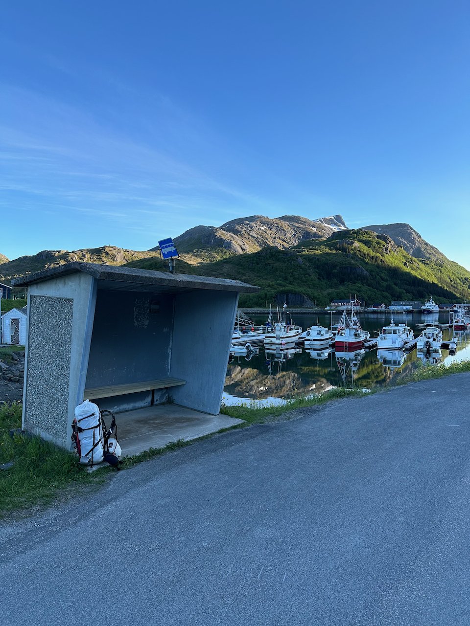
The Napp Ost bus stop
At a nearby stream, I rinsed my shoes and socks and snacked on my remaining food while I waited for the 9:15pm bus to whisk me smoothly back into reality. The bus would take me to Kablevåg where I had stashed my extra luggage and had booked a room at the simple but hospitable Lofoten Sommerhotell, a hostel style hotel that felt very welcoming to a damp, smelly mountain man.
The Route:
This was primarily a rugged hiking route, intermixed with some off-trail mountain travel, beautiful summit visits, white sand beaches and a bit of road walking. In the end it became a 100km, 62mi route which covered just over 17,700’ of elevation and was walked over the course of 6 days. Some miles went fast, others were difficult travel in inhospitable terrain. Invariably, the scenery made up for any shortcomings in the walking surface and each bog wallow would be offset by the wonders at hand.

Logistics:
The amazing public transit system in Norway was in invaluable partner in this enterprise, as I utilized the bus to get to the starting point of the hike in Sørvågen, to return from Napp to Kablevåg after the hike, and to get from Kablevåg to the Narvik airport for my exit. A one week Nordpass covered all of these rides at a total cost of $121.94. This also would have covered the ferry in the event that my overland linkup didn’t work at Helvetestinden.
Cost:
The total cost of groceries, dining, fuel, transportation and lodging over the course of these 6 days was $548. That’s less than $100/day to travel in one of the most expensive countries on earth. Not too shabby. It could be done for much less. I ate very well, had a few beers along the way and slept under a roof once. Reckon one could cut the cost in half if pressed.
Gear List:
Clothing

2 Sets OR Echo Boxer Briefs
1 T-Shirt - OR Echo Short Sleeve
1 Sun Shirt - OR Echo Hoodie
1 Windbreaker - OR Helium Wind Hoodie
1 Hardshell - OR Foray II Jacket
1 Synthetic Jacket - OR Superstrand LT Hoodie
1 Hybrid Pant - OR Cirque Light Pant
1 Shorts - OR Zendo Multi Shorts
2 Sets Stio Hiking Socks
1 Patagonia Capilene Lightweight Long Underwear
1 Baseball Hat - OR Swift Air Cap
1 Beanie - OR Drye Beanie
1 Lightweight Glove - OR Versaliner Sensor Liners
1 Overmitt- OR Revel Shell Mitts (w/o Liners)
1 Sunglasses - Julbo Fury Reactiv
1 Black Diamond Distance Gaiter
Hard Goods
Mountain Hardware Alpine Light Roll Top 45L Backpack
MSR Dynalock Ascent Carbon Backcountry Poles
Camping

Therm-a-Rest Neo Air XTherm NXT Pad
Therm-a-Rest Air Head Lite Pillow
MSR Pocket Rocket Deluxe Stove
8oz bottle of MSR Isobutane Fuel
4oz bottle of MSR Isobutane Fuel
Survival
Leatherman Skeletool Multi-tool
Basic First Aid Kit
Basic Repair Kit (tape, zip ties, binding bits, cord, etc.)
Compass
Firestarter Flint
ThinkSport SPF 50 Mineral Sunscreen
Photography
Fujifilm X70 Camera
3x Fujifilm X70 Batteries

I try to start, practice and end every foray into the mountains with gratitude. This trip is no different. Thanks to my family for holding down the fort and giving me an endless well of love to tap into during the lonely hours in the mountains. Thanks to Chase Jarvis and his whole crew for the commercial shoot that gave me an excuse to come to Norway in the first place. Thanks to the companies who support my efforts, including Outdoor Research, MSR, Therm-a-Rest, Mountain Hardware, and Black Diamond. And thank you, dear reader, for your interest and your support. Holler with any questions/comments. Till next time!
Leave a comment
This site is protected by hCaptcha and the hCaptcha Privacy Policy and Terms of Service apply.